The short version
Where a gate backs water up or the flow reverses, a canal station must measure water speed as well as water level. The Lodestar does it with one narrow beam of sound, slanted through the water at one spot across the channel, looking up from the bed or down from the surface. One beam brings six advantages:
- It reads the whole depth, near bed to near surface, around the clock, where a field crew's current meter reads one or two depths at each spot. At a well-sited station, its rating (the site's conversion chart) can need as few as 10 field measurements; a side-looking meter's rating often needs 20.
- It works in shallow water, too shallow for a beam aimed sideways.
- Each reading is local, so nothing depends on separate beams seeing the same water.
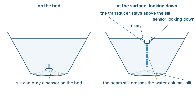
- It can measure from the surface, above the silt that buries sensors on the bed.
- On the bed, it can wear a weed cover, so crews make fewer trips to clear it.
- It is small and draws 2 watts.
It needs a straight reach with parallel flow, a mount that holds its angle, a separate water-level gage, and ratings built from field measurements. HyFlow can prepare a proposal for your site, drawing on our team's decades of combined deployment experience across the Asia-Pacific.
How a canal gaging station measures flow
Where backwater or reverse flow breaks the link between water level (stage) and flow (discharge), the station also records water speed in one part of the channel, the index velocity, with an acoustic Doppler velocity meter (ADVM). Ratings built from field measurements turn index velocity and water level into flow, as the first post in this series explains. The ADVMs in published guidance, the public method manuals hydrographers use, have two or more beams, looking up from the bed or sideways from a bank. So what does one beam buy you?
It profiles the water column, not one level
Water usually runs slower near the bed and faster higher up; how speed changes with depth is the vertical velocity profile. In a discharge measurement, a hydrographer reads it with a current meter at one or two depths on each vertical (the line from surface to bed at one spot), then moves on; published guidance calls reading the whole profile too slow for routine use. On the bed or at the surface, the Lodestar reads its vertical cell by cell, around the clock, so changes in the profile from backwater, reverse flow or wind show up in its record. The crew's measurements stay the reference, and the rating built from them relates that one spot to the whole channel.
A side-looking meter on a bank or wall reads one height, which sits at a different part of the depth as the water rises and falls, so its rating often needs the water level as a second input. Guidance asks for at least 10 calibration measurements (the field measurements a rating is built from) per input, so that rating needs at least 20. The Lodestar's cells, chosen from the water-level record, cover the same part of the depth, such as the middle 60 percent, however high the water is, as guidance prefers for up-looking meters. That removes one common reason for a second input, so at a well-sited station its rating can work from index velocity alone, with a minimum of 10 calibration measurements. Guidance also favors up-looking meters where the profile changes irregularly but flow stays even across the width.
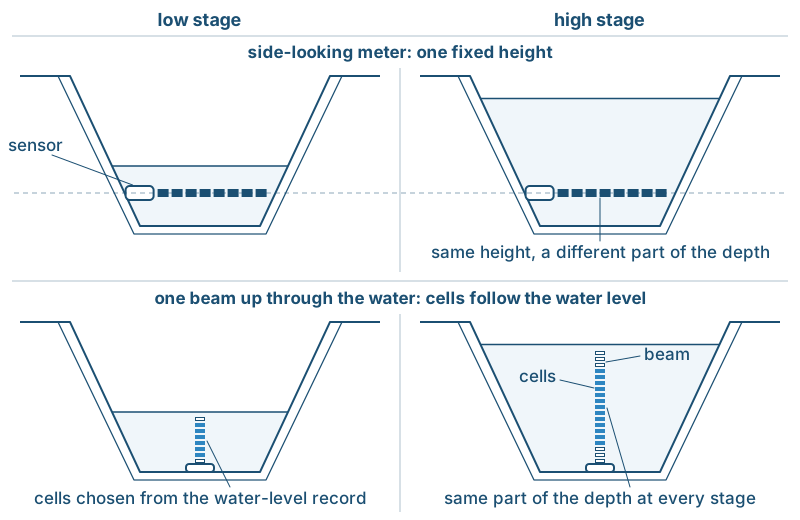
What that saves. Your gaging consultant, the firm that builds the ratings, makes the calibration measurements across the site's full range of flow, often with a boat-mounted acoustic Doppler current profiler (ADCP) its hydrographers bring to the site, such as a HyFlow Voyager. Where a side-looker's rating would need the water level and the Lodestar's would not, the minimum number of calibration measurements falls from 20 to 10: fewer crew days, and a usable record sooner. Drift is simpler to correct too: guidance applies a shift, a fixed amount added to or subtracted from the index velocity, only to ratings whose sole input is index velocity. Lasting drift needs a new rating on any meter.
In the field. Our team's experience includes a large-river station in the Asia-Pacific where two Lodestars each read one vertical, and a hydraulic model, not an index rating, turned those profiles, the water level and the surveyed cross section into discharge. Through a three-month flood season, the computed discharge stayed close to more than 50 manual discharge measurements, from low flow up to a peak of about 2,400 m³/s (85,000 ft³/s). In a winter low-flow period, it came within 4.3 percent of each of five measurements. A large river is not a canal.
It works in shallow water
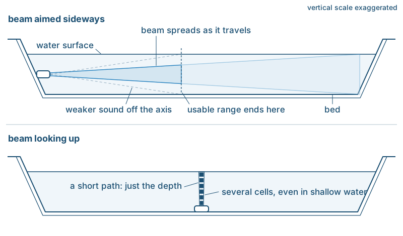
A beam aimed sideways needs water above and below it, and sound spreads: a 1.4-degree beam is about 0.5 m (20 in) wide at 20 m (66 ft). Aimed level at mid-depth in a canal 1 m (3.3 ft) deep, at that distance its edges come within about 25 cm (10 in) of the surface and bed, and weaker sound off its axis reaches them sooner. In shallow water its usable range shrinks, and cutting back a weak far end changes the water its rating was built on.
A beam looking up or down only has to cross the depth. The Lodestar measures from 0.05 m (2 in) off the transducer, in cells as small as 0.025 m (1 in), so a shallow canal still gets several cells, and guidance turns to up-looking meters where the water is too shallow for a side-looker. A Lodestar-U aimed level from a wall has the same limits as any horizontal beam.
Every cell is one small, local sample
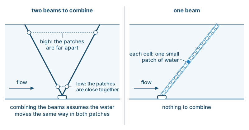
Meters with two or more beams combine them to separate speed along the channel from vertical or cross-channel motion. Their beams sample patches of water that lie farther apart the farther out they reach, so combining them assumes the water moves the same way in each: true in a straight, uniform reach, not always near walls, piers or gates, or when a side-looking meter is not level.
The Lodestar has nothing to combine. Each cell reports the water in that cell, and the narrow beam keeps cells small, about 25 cm (10 in) across at 10 m (33 ft). Its own assumption, flow parallel to the channel, is one published guidance asks of every index-velocity site.
It can measure from the surface
Published guidance calls up-looking meters a poor fit where moving sand or silt can bury the transducer. The Lodestar comes in three versions (the third post in this series covers the choice):
- Lodestar-B: on the bed looking up, for a firm bed that stays clear of silt, lined or not.
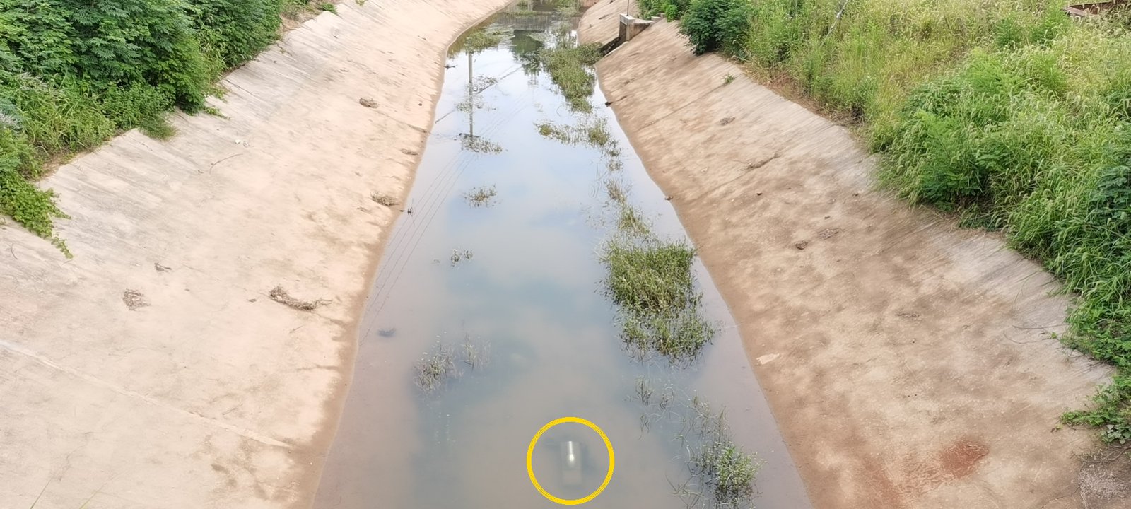
- Lodestar-S: at the surface looking down, usually on a buoy (a float anchored in place), sometimes from a fixed structure. The transducer stays above the sediment, and the beam still crosses the water column.
- Lodestar-U: a cylinder your installer's bracket holds on a wall, pier or abutment.
A cover keeps weed and trash off it
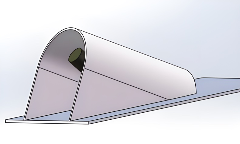
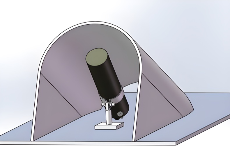
Weed and trash catch on a bed sensor and spoil its readings until a crew clears them. A multi-beam meter on the bed looks up through several faces, upstream and downstream, so it must sit uncovered. The Lodestar-B has one beam: face it downstream, and a streamlined cover over its top and upstream side lets debris slide past while the beam's path stays open. That keeps the readings clean between visits and saves crew trips to the hardest sensor to reach: one on the bed of a full canal. Where flow reverses, cover the side most debris comes from. The third post covers mounts and cable runs.
A short-range design in a small package
Frequency is a trade: for the same cell size and averaging time, a higher frequency gives a less noisy velocity and a shorter range, and at 1.7 MHz the Lodestar is short-range by design. Published guidance puts representative flow (water whose speed tracks the channel's mean) ahead of a large sample, and notes that on a wide river a well-placed short-range, high-frequency meter can do better than a long-range one.
Its beam is 1.4 degrees wide, with an acoustic profiling range of 0.05 to 20 m (about 2 in to 66 ft) along the beam. The standard housing is 240 by 75 mm (9.4 by 3 in) and weighs 1.2 kg (2.6 lb). It draws 2 W at 12 VDC while sampling, samples up to 10 times a second, and outputs signed velocity (plus one way, minus the other) over RS232 or RS485, so it measures flow in both directions.
What it asks of the site
Your gaging consultant will check four conditions:
- Flow parallel to the channel. One beam cannot tell a change in flow direction from a change in speed, and it reads vertical motion as speed along the channel, more so the steeper the beam. Guidance asks for a straight reach of at least about 300 ft (90 m) or 5 to 10 channel widths, whichever is longer, 5 to 10 widths from gates, drops, turnouts and inflows; backwater reaches far up a canal, so a backwater site can often keep that distance.
- A mount that holds its angle. A small change in tilt changes the reading, so a fixed mount must be rigid. Position matters less: a Lodestar looking up or down that sits a little off its old spot, on the bed or on a buoy, still reads roughly the same water column, so its index velocity barely changes. After each service it need go back only roughly where it was: fine-tuning the angle settings from its built-in 3D attitude sensor (tilt and compass) offsets any slight change in tilt. The attitude sensor also records a buoy's tilt. A beam level from a wall must go back exactly. If the mount is knocked or shifts, a check measurement (a fresh discharge measurement compared with the rating) confirms the record. HyFlow does not yet supply mounting hardware, but can propose a bracket design, and a weed cover for a bed mount, for your installer to build.
- Clean cells for the index. Cells by the housing sit in water it disturbs, and cells by the surface (or the bed, for a surface mount) are spoiled by echoes off it, so the index uses the cells between. Each cell's signal strength and signal confidence help pick them, and later help spot fouling.
- A water-level gage and ratings. The Lodestar does not measure water level, so the station needs its own gage, and your consultant builds the ratings from discharge measurements across the full range of flow, reverse flow included, plus periodic check measurements.
Where the Lodestar fits
The Lodestar is built for straight canal reaches where backwater or reverse flow breaks the link between water level and flow. Moving a rated station to another meter means a new index rating, so the choice is open at new stations and when a meter is replaced.
Unfamiliar term? See the plain-language glossary.
If your site backs up or flows in reverse, Request a Quote with the channel shape, the depth range and what is mounted there now. We will send a proposal for your site with the quote.